Live Weather Cameras
Real-time weather conditions from 12,925+ cameras across the US. Live temperature, wind speed, and sky conditions updated continuously via Open-Meteo.
Live US Weather Radar
Live precipitation radar powered by Windy. Zoom in for local detail or click to explore. Open full map
Current Conditions
 LIVE
LIVE
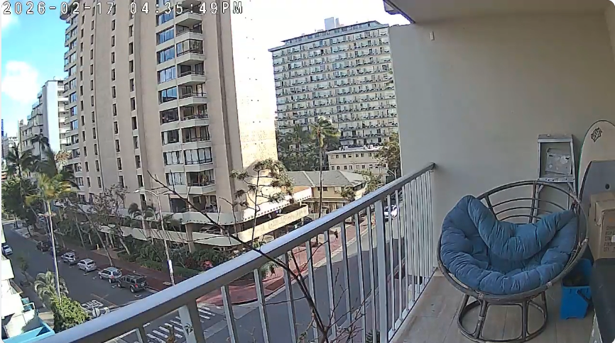
Lewers St Feed
Lewers Street, Waikiki, Honolulu, HI
Beluga Lake, Homer
Alaska
 LIVE
LIVE
Yosemite Half Dome
Yosemite Valley, California
 LIVE
LIVE
Mount Rainier — Paradise
Paradise, Washington
 LIVE
LIVE
Yellowstone — Mt Washburn
Yellowstone NP, Wyoming
 LIVE
LIVE
Acadia NP — Jordan Pond
Mount Desert Island, Maine
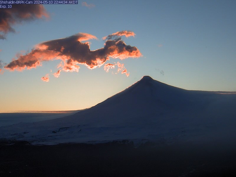
Volcano Watch
Monitor active and dormant volcanoes across Hawaii, Alaska, and the Cascades. The USGS and Alaska Volcano Observatory operate these cameras around the clock. Nighttime viewing during active eruption phases is often the most dramatic.


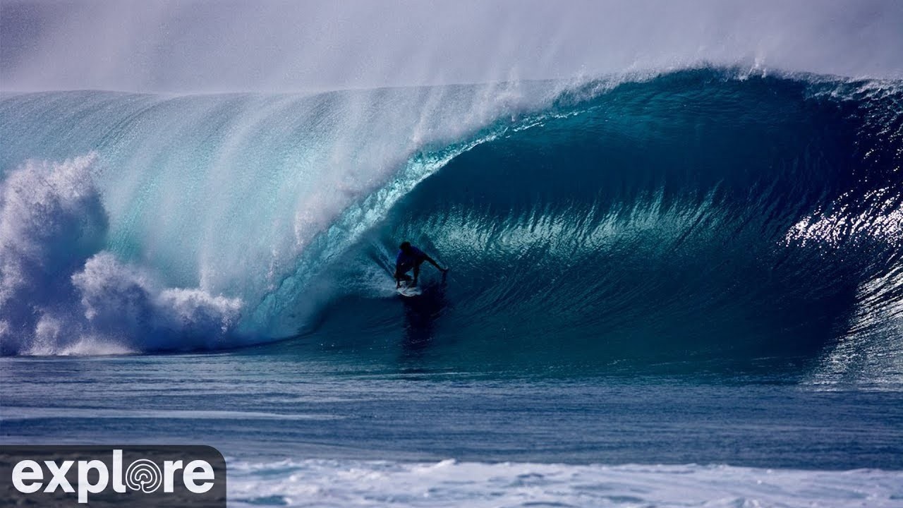
Surf and Ocean
Check real-time ocean conditions, wave height, and surf breaks from Hawaii to California. Each camera page includes detailed wave data and swell forecasts powered by NOAA marine buoys.

Mountain and Snow
Monitor snow conditions, visibility, and summit weather at ski resorts and mountain peaks from Alaska to Colorado. Ideal for checking conditions before heading to the slopes or planning a backcountry trip.
Aurora and Night Sky
Track aurora borealis activity with NOAA's northern hemisphere forecast map, and watch the night sky from high-altitude observatories above the clouds. The aurora forecast updates continuously and is most useful during dark hours at high latitudes.

GOES Satellite
NOAA GOES-18 satellite imagery showing real-time cloud patterns, storm systems, and weather fronts. The geocolor composite combines visible and infrared data for a natural-looking view of the atmosphere from space.

Why Watch Live Weather Cameras?
Weather forecasts give you a prediction. Live cameras give you proof. When a forecast says "partly cloudy" at your destination, a live camera shows you exactly what that looks like on the ground -- whether that means blue skies with a few wisps of cloud or a thick marine layer obscuring the view. For surfers checking swell before driving to the coast, skiers evaluating snow coverage before a long mountain trip, or photographers chasing the perfect light, there is no substitute for a real-time visual.
Port of Cams aggregates live weather cameras from government agencies including NOAA, the USGS, Alaska Volcano Observatory, FAA WeatherCams, and state DOT networks across all 50 states. Our volcano cameras stream active eruption sites at Kilauea and across the Aleutian Islands. Mountain cameras at elevations from 5,000 to 14,000 feet show real-time snow depth, rime ice buildup, and cloud deck position. Coastal cameras capture wave conditions, tidal changes, and approaching storm fronts.
Every camera page on Port of Cams displays current weather data alongside the live feed -- temperature, wind speed, humidity, and a plain-language condition description. You can monitor conditions at any of our 12,925+ cameras without leaving the site. Combined with our GOES satellite imagery and NOAA aurora forecast, this page gives you a complete weather picture from the ground to space.
Frequently Asked Questions
How do weather cameras differ from weather forecasts? +
Weather cameras show you actual, real-time conditions at a specific location. Unlike forecasts that predict what might happen, live cameras let you see current visibility, precipitation, cloud cover, and sky color as they are right now. This is especially useful for outdoor activities where local conditions vary significantly from regional forecasts.
How often does the weather data update on camera cards? +
The temperature and conditions shown on each camera card are fetched live from the Open-Meteo weather API when you load the page. The data reflects current conditions at each camera location, updated every 15 minutes by the weather service. Camera images refresh on their own schedule, typically every 1 to 10 minutes depending on the source.
Can I use these cameras for storm tracking? +
Yes. Our volcano, mountain, and coastal cameras are valuable for monitoring approaching storms, snow accumulation, wave height changes, and visibility drops in real time. Many DOT traffic cameras across 50 states also show road conditions during winter storms. The GOES satellite view provides large-scale cloud pattern tracking across the entire Pacific or continental US.
What are the best cameras for watching volcanic activity? +
Our Volcano Watch section features cameras at Kilauea on the Big Island of Hawaii, Mauna Loa Observatory, Mt St Helens in Washington, and Shishaldin Volcano in Alaska. During active eruption phases, nighttime viewing is most dramatic when lava glow illuminates the crater. The USGS and Alaska Volcano Observatory operate these cameras continuously.
Do the cameras work at night? +
Many cameras continue streaming at night, though visibility depends on the camera hardware and location lighting. Volcano cameras are often most spectacular after dark. The Aurora Forecast map updates around the clock. Urban and resort cameras typically have enough ambient light for nighttime viewing. Mountain and wilderness cameras may show limited visibility after sunset.