About This Camera
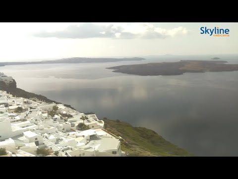
This camera looks out over the caldera of Santorini, the crescent-shaped Greek island in the southern Aegean that is the rim of a massive volcano. Around 1600 BC one of the largest eruptions in human history blew out the center of the island, leaving the dramatic cliffs that today drop hundreds of feet straight to a flooded caldera — and gave rise to some of the legends of lost Atlantis. The whitewashed villages of Fira and Oia cling to the clifftops, their blue-domed churches and cave houses stacked above the deep blue water.
Santorini is on Eastern European Time, 13 hours ahead of Hawaii. The island is famous above all for its sunsets — the view west across the caldera at dusk draws crowds to Oia every evening — so the most spectacular feed is in the island's late-afternoon and evening hours. Daytime shows the cruise ships anchored in the caldera and the ferries running to the other Cyclades.
The little islets in the center of the caldera, Nea Kameni and Palea Kameni, are the still-active volcanic cones, with hot springs and a hikeable crater. Santorini is also known for its dramatic black- and red-sand beaches, its Assyrtiko white wines grown in volcanic soil, and the Bronze Age ruins of Akrotiri.
Advertisement
You Might Also Like
Fetching local weather…
📈 Volcano & Seismic Activity
PRO 🔒
Volcano & Seismic Activity — Premium
Live alert level cues and recent earthquakes near the cam.
Unlock Premium — $1 first monthAlready Premium? Sign in to view.
Forecast data: Open-Meteo · NOAA SWPC · USGS. Conditions are estimates.
Recommended Gear

As an Amazon Associate, we earn from qualifying purchases.
Things to Do Nearby
Advertisement