No matching pages. Try a place, activity, or tool name.
THE GARDEN ISLAND · SOUTH SHORE TO NORTH SHORE · LIVE
Kauaʻi Live Cams: Poʻipū, Hanalei Bay and the North Shore
Kauaʻi’s weather depends on which side of the island you are on. The trade winds bring most of the rain to the north and east, and the south shore around Poʻipū, in their lee, is typically the sunny side. These are the live cameras on Kauaʻi we carry, shore by shore, with a side-by-side look at the weather on each coast right now, and an honest note on the north shore, where no streaming camera is live at the moment.
Tuesday, October 27 at 9:08 AM HST
Daylight on Kauaʻi.
South shore or north shore: which is drier right now?
The north shore (Hanalei and Princeville) looks drier right now than the south shore (Poʻipū), against the usual pattern.
Poʻipū South shore
Overcast · 77°F · 95% cloud
Next 6 hours: 0.26 in of rain forecast, 99% cloud on average.
Wind NE 9 mph.
Līhuʻe East shore
Overcast · 77°F · 93% cloud
Next 6 hours: 0.22 in of rain forecast, 98% cloud on average.
Wind NE 7 mph.
Hanalei and Princeville North shore
Overcast · 75°F · 100% cloud
Next 6 hours: 0.02 in of rain forecast, 100% cloud on average.
Wind ESE 3 mph.
Open-ocean waves now: off the north shore 6.7 ft from the NNW at 12 s; off the south shore 4.2 ft from the S at 12 s. That is the model’s deep-water wave height, not the breaking surf on the beach.
Open-Meteo forecast models, as of 9:00 a.m. HST. A model cell is a few miles across and Kauaʻi’s showers are local, so treat this as a guide and check the cams.
Typically the south shore is the drier side, and the difference is biggest in winter (see the rain pattern below). Weather from Open-Meteo, refreshed in your browser.
Cameras and frames checked by hand on 25 October 2026. Streams re-checked when this page was rebuilt: 3 of 3 live; 1 not checkable then.
South shore: Poʻipū and Lāwaʻi
Kauaʻi’s south shore sits in the lee of the trade winds, so it is usually the sunnier, drier side. All three south-shore cameras are within about three miles of each other around Poʻipū.
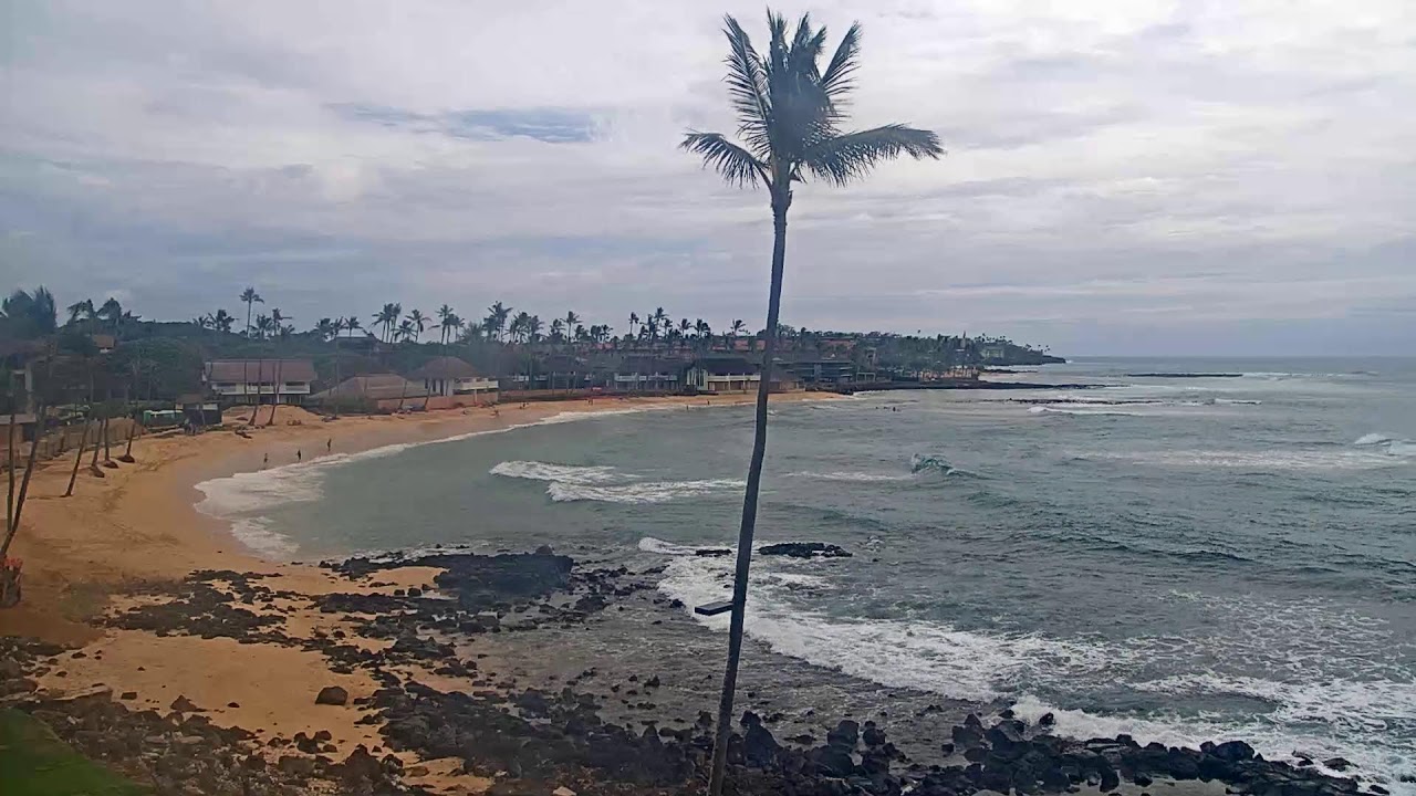
From above the lava rocks at the resort, the camera follows the curve of sand east towards Poʻipū Beach Park, with turquoise water inside the reef and the deep blue of the open south-shore ocean filling the right of the frame. Brennecke’s Beach is at the far end of that stretch, about a kilometre away, beyond the beach park.
Faces: East along Poʻipū Beach, with the open ocean on the right
What you’ll see: Swimmers and snorkelers inside the reef, waves breaking on the rocks in the foreground, and the size of the south swell on the outer reefs.
When: All day; in the early morning the sun is low in front of the camera.
A wide view from the resort over a lawn and a row of palms to the shoreline road and the ocean beyond, with a line of white water where the waves break on the reef.
Faces: South across the lawn and Lāwaʻi Road to the ocean
What you’ll see: The palms show the trade wind at a glance; the reef line shows how much south swell is running.
When: Daylight, Hawaiʻi time; it looks south, towards the sun, so expect some glare on the water around midday in winter.
The course’s own camera, looking over greens, bunkers and leaning coconut palms to the hills behind the south shore. There is little ocean in this view; it is the camera to check for the sky and the wind.
Faces: Across the fairways to the mountains inland
What you’ll see: Cloud building over the mountains, and how hard the palms are bending in the trades.
When: Daylight, Hawaiʻi time.
East shore: Līhuʻe and Kalapakī Bay
The east side faces the trade winds, and the National Weather Service notes that rain is much greater on windward coasts than in the lee, so it sees more passing showers than Poʻipū.
From high on the resort, a view over its pools and Kalapakī Beach to the harbor mouth, with the green ridge of Hāʻupu rising on the right. It plays in Ozolio’s own player.
Faces: South-east over Kalapakī Beach to Nāwiliwili Harbor’s breakwater
What you’ll see: Paddlers and surfers in the bay, and boats and ships coming in past the breakwater to Nāwiliwili Harbor.
When: Daylight, Hawaiʻi time.
North shore: Hanalei and Princeville
The wettest of the coasts here, and in winter the one that takes the big north swells. There is no streaming camera on the north shore on Port of Cams right now. The two Hanalei Bay cameras we listed, at the Hanalei Colony Resort and Hanalei Bay Resort, both played through the same Windy player, which stopped working in 2026, and we have not found a public live stream of Hanalei Bay to put in their place. Rather than stand another view in for it, these are the FAA’s weather cameras on that side of the island, on our traffic and weather site:
Princeville Airport weather cameraThe FAA’s camera at Princeville: four still views (north-east, south-east, south-west, north-west), refreshed every 5–10 minutes. The quickest way to see whether it is raining on the north shore.
Powerline Trail weather cameraAn FAA camera a few miles inland of Princeville, four still views refreshed every 5–10 minutes: cloud and rain over the hills.
They are aviation cameras, not beach cams: still frames every few minutes, made for pilots to judge cloud and visibility. They are still the quickest way to see whether the north shore is under cloud or rain.
Why the south shore is usually sunnier
Hawaiʻi’s weather is set by the north-easterly trade winds. In the National Weather Service’s words, when warm, moist air rises over windward coasts and slopes, clouds and rainfall are much greater than over the open sea, while leeward areas, where the air descends, tend to be sunny and dry. Kauaʻi’s north and east coasts face the trades; Poʻipū, on the south shore, is in their lee.
The NWS describes two seasons: a drier “summer” from May to October and a “winter” from October to April, the season of more frequent clouds and rainstorms. The long-term averages show how big the gap between the coasts is:
NOAA normals, 1991–2020
A year · December–February · June–August
Līhuʻe AirportEast shore
36.22 in · 11.05 in · 5.87 in
Princeville RanchNorth shore
75.17 in · 20.09 in · 16.72 in
So Princeville, on the north shore, gets about twice Līhuʻe’s rain in a year (75.17 inches against 36.22). NOAA has no rainfall normal for a Poʻipū station; Līhuʻe, on the east side near the airport, stands in for the drier lowlands. The classic winter picture, sun on the south shore while Hanalei is grey, is a typical pattern, not a promise: the NWS notes that dry leeward areas get most of their rain from a few winter storms, and when one of those comes through, the south shore gets wet too.
From about November to March, storms in the North Pacific send swells to Hawaiʻi’s north-facing shores, and Hanalei and Princeville face straight into them. The National Weather Service in Honolulu forecasts Kauaʻi’s surf separately for north-, west-, south- and east-facing shores every day, and the wave heights in the weather box above show which coast has more swell right now. For conditions at a particular beach, ask a lifeguard or call the Kauaʻi Ocean Safety Bureau on 808-241-4984.
For the bigger picture, our Hawaii big wave season page has the 7-day swell outlook for Oʻahu’s North Shore and Peʻahi, the live Pipeline cam, and how a swell that shows on the buoy north-west of Kauaʻi reaches the islands.
Monk seals and sea turtles: how close is too close
Hawaiian monk seals live nowhere else in the world. NOAA puts the population at about 1,600, about 400 of them around the main Hawaiian Islands, and says they usually sleep on beaches, sometimes for days at a time; NOAA’s own page shows a sign on Kauaʻi’s south coast asking beachgoers to give a resting seal space. The camera operators do not promise wildlife, so neither do we, but if you are on the beach in person, NOAA recommends:
Hawaiian monk seals: at least 50 feet (15 m) away, on land and in water.
A mother with a pup: at least 150 feet (about 45 m).
Sea turtles: at least 10 feet (3 m), on land and in water.
Report a sick, injured or stranded animal to the NOAA Marine Wildlife Hotline, (888) 256-9840, and harassment to (800) 853-1964 or (808) 643-DLNR (3567).
Daylight in Hawaiʻi. The beach cameras show nothing useful after dark. Hawaiʻi has no daylight saving time, so a Kauaʻi morning is midday to early afternoon on the US mainland.
Poʻipū, the 15th of
Sunrise · sunset (HST)
December
7:10 a.m. · 5:58 p.m.
January
7:20 a.m. · 6:16 p.m.
March
6:47 a.m. · 6:48 p.m.
June
5:55 a.m. · 7:23 p.m.
September
6:26 a.m. · 6:42 p.m.
Sunrise and sunset computed for Poʻipū from the sun’s position (SunCalc).
Questions
Is there a live cam at Hanalei Bay?
Not a streaming one right now. The two Hanalei Bay cameras we listed went offline in 2026 and we have not found a public live stream on the north shore to replace them. The nearest live look is the FAA’s Princeville Airport weather camera, four still views refreshed every 5–10 minutes, which shows the cloud and rain over the north shore. The live cameras on this page are on the south and east shores.
Which side of Kauaʻi is sunnier, north or south?
Usually the south. Hawaiʻi’s trade winds blow from the north-east, so rain falls mostly on windward coasts and slopes, and the National Weather Service notes that leeward areas, where the air descends, tend to be sunny and dry. On Kauaʻi that typically means the south shore around Poʻipū is the drier side and the north shore around Hanalei and Princeville the wetter one. It is a pattern, not a rule: the comparison near the top of this page shows what the forecast models say right now.
When is the rainy season on Kauaʻi?
The National Weather Service describes two seasons in Hawaiʻi: a drier summer from May to October and a winter from October to April, the season of more frequent clouds and rainstorms. The north shore is wet all year: NOAA’s 1991–2020 normals give Princeville Ranch 75.17 inches a year (20.09 in December to February), against 36.22 inches at Līhuʻe Airport (11.05 in December to February).
Can you see monk seals or sea turtles on the Poʻipū cams?
None of the camera operators promises wildlife, so we do not either. Hawaiian monk seals live only in Hawaiʻi, about 400 of them around the main islands, and NOAA says they usually sleep on beaches, sometimes for days at a time. If you meet one, NOAA recommends staying at least 50 feet (15 m) away, 150 feet (about 45 m) from a mother with a pup, and at least 10 feet (3 m) from a sea turtle. Report a sick or injured animal to the NOAA Marine Wildlife Hotline at (888) 256-9840.
When is the surf big on Kauaʻi’s north shore?
In winter, when storms in the North Pacific send swells to north-facing shores; Hanalei and Princeville face into them. The National Weather Service in Honolulu forecasts Kauaʻi’s surf by shore (north, west, south and east facing) every day. For conditions at a beach, ask a lifeguard or call the Kauaʻi Ocean Safety Bureau on 808-241-4984. Our Hawaii big wave season page has the 7-day North Shore swell outlook.
Where is Brennecke’s Beach, and is there a camera on it?
Brennecke’s Beach is in Poʻipū on the south shore, at the east end of Poʻipū Beach Park. No camera we carry looks straight at it. The Sheraton Kauaʻi camera looks east along Poʻipū Beach towards the beach park from about a kilometre away, so it shows the same stretch of coast and the same swell and weather.
What time is it on Kauaʻi?
Kauaʻi is on Hawaii-Aleutian Standard Time (HST), UTC−10, all year: Hawaiʻi does not use daylight saving time. That puts it two hours behind the US West Coast in winter and three in summer, and five hours behind New York in winter and six in summer. The clock at the top of this page shows the time there now.
Camera feeds belong to their operators (Ozolio for Sheraton Kauaʻi and Royal Sonesta Kauaʻi, Lāwaʻi Beach Resort, Poʻipū Bay Golf Course), named on each camera page; the north-shore links are FAA WeatherCams. Weather and waves are from Open-Meteo’s models, fetched by your browser; climate facts from the National Weather Service and NOAA NCEI; wildlife distances from NOAA Fisheries.
THE WORLD IS ALWAYS ON.
A WINDOW TO SOMEWHERE ELSE
Start somewhere:
POCTIX · FOR VENUES & ORGANIZERS
Bring your stage to audiences everywhere.
Sell tickets for the room. Make a plan to stream your next show beyond it.
We use cookies for analytics and ad personalization. Decline keeps the site working;
Accept helps us improve and supports our free streams.
Learn more.